Loading
Showing posts with label Open source. Show all posts

2.14.2012

GVL


Google Vector Layers (Project)


Google Vector Layers allows you to easily add one or more vector layers from a number of different geo web services to a Google Maps API based application.


Overlaying custom vector layers (CartoDB) on-top of Google Maps - An excellent use of geojson


How it works?
Google Vector Layers works by listening to map events (pan and zoom) and then fetching features within the map bounds after each event. This method works great for data sets with lots of features that you want to interact with, but not load all at once.

Features:
  • Multi-Provider Support - Current support for ArcGIS Server, Arc2Earth, Geocommons and CartoDB (with more in mind)
  • Easy InfoWindow Templating - Create InfoWindow templates with a simple string with property names {mustached} or with a function that gets passed feature properties, and should return valid HTML for the InfoWindow
  • Dynamic Data Support - Easily visualize live data that auto-updates at an interval that you set (and makes sense for your data’s update frequency)
  • Simple, Powerful Symbology - Style your layers with a single symbology, a unique symbol for specific attribute values or set symbols to display if a feature’s attibutes are within a specific range. Or …
  • Use Your Current Styles - If you’re using an ArcGIS Server layer you can use the styles you’ve already spent time creating in ArcMap
  • Scale Dependent Rendering - You wouldn’t want to show lots of features with complex geometries at lower zoom levels - UsingscaleRange lets you set the minimum and maximum scales a layer should be visbible

2.10.2012

GRASS,GVSIG,QGIS confused?


  • GRASS has grown in terms of # of developers until 2008 this growth has since then stabilized
  • gvSIG had a peak between 2006 and 2008, during which they seemed to have become the desktop GIS software open spurce reference, but its growth was reduced in both terms, contributions in releases in terms of No. of developers involved
  • QGIS has had strong growth both in terms of contributions in the releases of both in terms of # of developers between 2004 and 2008 with a trend of steady growth that has taken every 4 years to double the # of developers involved so maybe today is the good tool among open gis desktop reference sources

2.06.2012

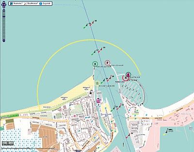
OpenSeaMap – Free Nautical Map

OpenSeaMap is project to create some free nautical map and geographic data such as lights and buoys with contributions both from official public data (with no copyright) and passionated individuals. OpenSeaMap is part of OpenStreetMap and has created a cool online editing interface that allows anyone to spend his experiences and contribute to the map.
OpenSeaMap includes marine lights , buoys and other navigation signals, port information , repair shops , craft supplies and more. Also included are other associated services such as shops , restaurants and attractions. This is not yet fully developed and it is mainly available in Germany.
As the backend structure for the data is based on the s-57 vector format (used by official ENC), it could be a good tool to develop some cartographic online interface for implementing the info from the official Notices to Mariners (NTMs) which provides timely marine safety information for the correction of all the official navigation paper charts.

1.18.2012

Mapstraction:Google maps alternative!


Mapstraction is a library that provides a common API for various javascript mapping APIs to enable switching from one to another as smoothly as possible. Developers can code their applications once, and then easily switch mapping provider based on project needs, terms and conditions, and new functionality.
Users can switch maps as desired based on personal taste and quality of maps in their local area. Various tools built on top of Mapstraction allow users to easily integrate maps into their own sites, and configure them with different controls, styles, and provider.

Major Features

  • Support for all major mapping providers
  • Dynamic switching of provider
  • Point, Line, Polygon, GeoRSS, KML support
  • Image overlay and base tiles
  • Open-source - we welcome your contributions!
  • Friendly community


1.15.2012

OSSIM - Open Source Software Image Map

OSSIM is a high performance software system for remote sensing, image processing , geographical information systems and photogrammetry. It is an open source software project maintained at www.ossim.org and has been under active development since 1996. The lead developers for the project have years of experience in commercial and government remote sensing systems and applications. OSSIM has been funded by several US government agencies in the intelligence and defense community and the technology is currently deployed in research and operational sites. The name OSSIM is a contrived acronym (Open Source Software Image Map) that is pronounced “awesome” – the acronym was established by our first government customer.
                                                                                                                                                               
 download 

1.13.2012

Diva

DIVA-GIS

DIVA-GIS is a free computer program for mapping and geographic data analysis (a geographic information system (GIS). With DIVA-GIS you can make maps of the world, or of a very small area, using, for example, state boundaries, rivers, a satellite image, and the locations of sites where an animal species was observed. We also provide free spatial data for the whole world that you can use in DIVA-GIS or other programs.
You can use the discussion forum to ask questions, report problems, or make suggestions. Or contact us, and read the blog entries for the latest news. But first download the program and read the documentation.
DIVA-GIS is particularly useful for mapping and analyzing biodiversity data, such as the distribution of species, or other 'point-distributions'. It reads and write standard data formats such as ESRI shapefiles, so interoperability is not a problem. DIVA-GIS runs on Windows and (with minor effort) on Mac OSX (see instructions).
You can use the program to analyze data, for example by making grid (raster) maps of the distribution of biological diversity, to find areas that have high, low, or complementary levels of diversity. And you can also map and query climate data. You can predict species distributions using the BIOCLIM or DOMAIN models.

Source: http://www.diva-gis.org/node/1

Open EV

What is OpenEV?

OpenEV is a software library and application for viewing and analysing raster and vector geospatial data.
OpenEV is used by private companies, universities, governments and non-profit organizations around the world. OpenEV is both:
  • An application for displaying and analysing geospatial data
  • A developer library from creating new applications
OpenEV is released under the GNU LGPL license Open Source license. It is available for Windows, Linux, Sun Solaris, and SGI Irix operating systems.

Download OpenEV Now!