Loading
Showing posts with label NEW TOOLS. Show all posts

2.06.2012

OpenSeaMap – Free Nautical Map

OpenSeaMap is project to create some free nautical map and geographic data such as lights and buoys with contributions both from official public data (with no copyright) and passionated individuals. OpenSeaMap is part of OpenStreetMap and has created a cool online editing interface that allows anyone to spend his experiences and contribute to the map.
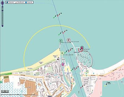
OpenSeaMap includes marine lights , buoys and other navigation signals, port information , repair shops , craft supplies and more. Also included are other associated services such as shops , restaurants and attractions. This is not yet fully developed and it is mainly available in Germany.
As the backend structure for the data is based on the s-57 vector format (used by official ENC), it could be a good tool to develop some cartographic online interface for implementing the info from the official Notices to Mariners (NTMs) which provides timely marine safety information for the correction of all the official navigation paper charts.

1.09.2012

Scribble Maps


There are many online applications available that encourage the creation, usage, and sharing of maps among professionals, classmates, and friends. Scribble Maps Pro is one that not only targets both the novice and expert map creator, but unlike its similar counterpart Google Earth Pro, it doesn’t require any special downloads - and it’s free. Its ease of use and accessibility makes it one of the most popular applications in the education sector, offering users a wide range of capabilities, such as marking up maps, measuring distances, importing KMLs, Shapefiles, as well as tabular files, adding placemarks, text, images, shapes and more. Scribble Maps Pro also provides support for Open Street Map and Cloud Made, enabling users to utilize Scribble Map Pro features onto either of these two mapping applications. Similar to Google Maps, this product also offers search capabilities, so users can search for either a geographical area, or a business. Finished map products can easily be shared with links, widgets, as well as be exported as images, KML and GPX files.
Scribble Maps Pro is a flash based application that is currently available in two versions - Scribble Maps, and Scribble Maps Pro. This review will focus on Scribble Maps Pro, the more advanced GIS mapping platform of the two.
Scribble Map

NOAA v-Datum - tidal, orthometric and ellipsoidal vertical datums

A useful transformation tool from NOAA - vDatum. VDatum is a free software tool being developed jointly by NOAA's National Geodetic Survey (NGS)Office of Coast Survey (OCS), and Center for Operational Oceanographic Products and Services (CO-OPS). VDatum is designed to vertically transform geospatial data among a variety of tidal, orthometric and ellipsoidal vertical datums - allowing users to convert their data from different horizontal/vertical references into a common system and enabling the fusion of diverse geospatial data in desired reference levels.

http://vdatum.noaa.gov/ 

Generalized Environmental Modeling System for Surfacewaters (GEMSS®)


Good News for Environmental-science researchers!


The Surfacewater Modeling Group has encapsulated many of its analysis techniques in the software system GEMSS® (Generalized Environmental Modeling System for Surfacewaters). At the heart of the system are four hydrodynamic modules: the 3-D model GLLVHT (z-grid and sigma-grid), the 2-D longitudinal-vertical model CE-QUAL-W2, the 1-D model GLHT, and the 0-D (fully-mixed) model RTC.

In addition, GEMSS® includes the following constituent modules:
Water Quality Module - WQM
Sediment Transport Module - STM
Toxics Module - TOX
Particle Tracking Module - PTM
Chemical and Oil Spill Impact Module - COSIM
Thermal Analysis Module - TAM
Generalized Bacterial Module - GBM
Generalized Algal Module - GAM
Entrainment Module - ENM
jump to site

1.07.2012

tutorials!

http://www.globalpositions.com/knowgis.html

Check the tutorials from KnowGIS . KnowGIS™ Training Series is an training course for learning and knowing ArcGIS ® Desktop. Using innovative training techniques, real-world project,s and on-screen demonstrations, Jere Folgert, Training Host, shares his real-world knowledge on how to maximize the power of ESRI's integrated suite of applications which make up ArcGIS® Desktop. Participants watch and learn about ArcCatalog, ArcMap, and ArcToolbox..


I kinda liked it...but alas No material for ArcGIS10.

1.06.2012

forestry GIS

http://www.forestpal.com/fgis.html


It is free!It works!.... Fgis arranges geographic themes (layers) in a simple table of contents. The order of layers can be changed by dragging them up or down. Layers can be made semi-transparent if needed to view information underneath. Symbols, lines and fills can be changed with flexible property menus. Users can add their own point, line or area objects by tracing over aerial photos or other maps. Length and area values in US or metric measures are calculated automatically. Users can also import tabular and GPS data.

1.05.2012

TatukGIS viwer

http://www.tatukgis.com/products/viewer/viewer.aspx

The free TatukGIS Viewer opens most GIS/CAD vector, raster image, and grid file types, including the aerial imagery and vector street map data provided by the leading vendors, most ArcView, ArcExplorer, and MapInfo projects, and projects exported from ArcGIS/ArcMap using the free Arc2TatukGIS plug-in. Besides just opening and viewing map files and attribute data, the Viewer includes a comprehensive visual layer properties control, legend control, attribute data table, features for thematic mapping, spatial and attribute querying, custom labeling, on-map measurements, hyper-linking, PDF export and much more. The user interface is available in 16 language options.

Because the GIS Viewer is compiled from the TatukGIS Developer Kernel (DK) product, it provides good example of a DK based application and an easy way to evaluate the TatukGIS technology and support for various data formats and common GIS functionality. The free Viewer can be used to generate TatukGIS project files that are compatible with any other TatukGIS product or custom applications developed from the TatukGIS DK product. The Viewer can also be useful for generating ASP.NET projects for web publishing with the TatukGIS Internet Server