Loading
Showing posts with label DATA. Show all posts

2.06.2012

OpenSeaMap – Free Nautical Map

OpenSeaMap is project to create some free nautical map and geographic data such as lights and buoys with contributions both from official public data (with no copyright) and passionated individuals. OpenSeaMap is part of OpenStreetMap and has created a cool online editing interface that allows anyone to spend his experiences and contribute to the map.
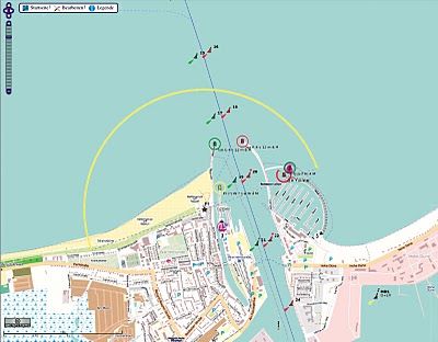
OpenSeaMap includes marine lights , buoys and other navigation signals, port information , repair shops , craft supplies and more. Also included are other associated services such as shops , restaurants and attractions. This is not yet fully developed and it is mainly available in Germany.
As the backend structure for the data is based on the s-57 vector format (used by official ENC), it could be a good tool to develop some cartographic online interface for implementing the info from the official Notices to Mariners (NTMs) which provides timely marine safety information for the correction of all the official navigation paper charts.

1.22.2012

Tera SAR X


The German Earth observation satellite TanDEM-X, together with its twin satellite, TerraSAR-X, have completely mapped the entire land surface of Earth after only a year of service.
The data is being used by the German Aerospace Center (Deutsches Zentrum fur Luft- und Raumfahrt; DLR) – which controls both radar satellites – to create the world's first single-source, high-precision, 3D digital elevation model of Earth.
Over the last year, the two radar satellites have been moving through space in close formation – at times just a few hundred metres apart. Strip by strip, they have recorded Earth from different angles and transmitted high-resolution radar data from their orbit at an altitude of 514 kilometres down to the three ground stations - Kiruna (Sweden), Inuvik (Canada) and O'Higgins (Antarctica).

1.18.2012

The Google Public Data Explorer

A handy data visualization resource from Google - The Google Public Data Explorer makes large datasets easy to explore, visualize and communicate. As the charts and maps animate over time, the changes in the world become easier to understand. You don't have to be a data expert to navigate between different views, make your own comparisons, and share your findings. 

http://www.google.com/publicdata/home